


It looks as though an early season September storm is blowing into the American West later this week. The news is being received extremely well as fires continue to decimate much of the West Coast all the way to Montana. The storm, which is blowing down from Alaska’s Bering Sea, should be cold enough to create accumulation above 6,500′ with rain below that elevation. Whatever the case, California needs all it can get.
NOAA is even calling for up to 6” on the high peaks of Idaho!
Here are the regional outlooks.
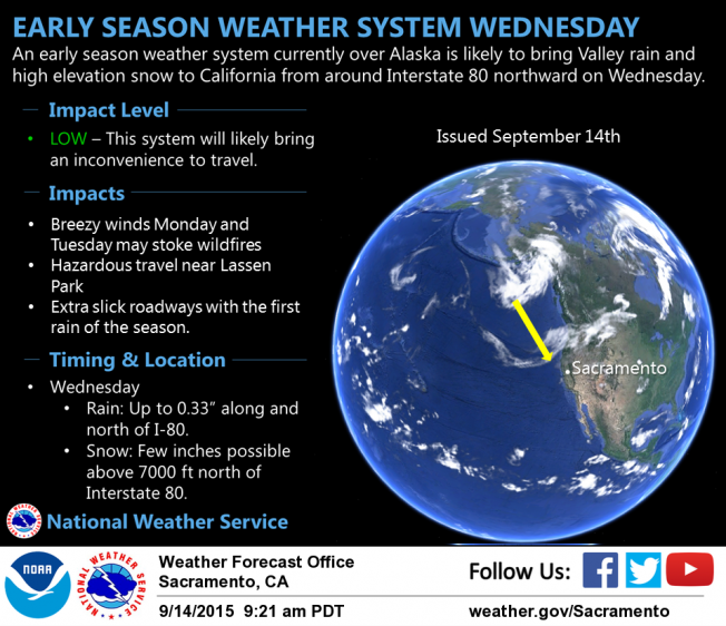
California

“We may have an early season weather system heading our way! A weather system currently situated over Alaska is forecast to move toward Northern California, potentially spreading precipitation south to around the Interstate-80 corridor. Rain amounts of up to 0.33″ will be possible, mainly along the far Northern Sacramento Valley. Snow levels may also drop down to around 7000 ft, meaning possible snow for Lassen Park and perhaps a dusting near Donner Pass. We currently believe this will bring rain to the Valley Fire, but not the Butte Fire. Stay tuned for updates!”– National Weather Service, Sacramento
Idaho


“A series of weather disturbances will keep weather active through much of the week. The first disturbance will trigger some showers and isolated thunderstorms this afternoon. A second system tomorrow will drop snow levels to the Central Mountains and bring 4 to 6 inches of snow to the peaks. Temperatures across the area will drop into the mid-30s across the Snake Plain Thursday and Friday nights—cold enough that we may see pockets of frost develop.”– NOAA Pocatello
Wyoming

“WEDNESDAY AND THURSDAY…UNSETTLED WEATHER PATTERN CONTINUES WITH SCATTERED TO NUMEROUS SHOWERS AND ISOLATED THUNDERSTORMS IN THE WEST. WINDY AREAS WITH ISOLATED TO SCATTERED SHOWERS AND A FEW THUNDERSTORMS ACROSS THE CENTRAL AND SOUTH. SNOW WILL OCCUR IN THE MOUNTAINS ABOVE 9500 FEET IN THE WEST AND NORTH.” – NOAA
Montana

“Any outdoor plans this week? A series of weather systems are expected to track into north-central Idaho and western Montana beginning Monday afternoon and continuing off and on through the rest of the week. This will bring snow showers to higher elevations and rain showers to the lower elevations. Those planning outdoor activities should prepare for wet, raw, and cold conditions.”– NOAA Missoula
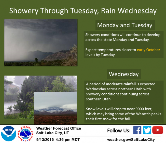
Utah

“As the fall season approaches, the weather is in a transition. Expect showery conditions across Utah Monday and Tuesday. Temperatures will feel closer to early October levels by Tuesday across much of the state. On Wednesday, a period of moderate rainfall is expected across northern Utah, with showery conditions continuing across the southern half of the state. Snow levels will drop to near 9000 feet Wednesday, which may bring the first snow of the fall to some of the Wasatch peaks.”– NOAA Salt Lake City